Complete The Picture With Seamless Geographic Boundaries
Our precision geofence boundaries provide hyper-local relevance for all your geographic analysis and mapping needs.
For years, Location, Inc. has been offering the most detailed analytical data for relevant geographic areas. Now those geographic boundaries or geofences are available for your use in a single, complete package. Whether you are interested in our neighborhoods because you are familiar with viewing NeighborhoodScout, or you want to cross reference ZIP codes to major metro areas, our Geofence Boundary Package has the data that you need.
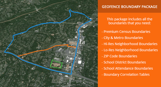
The boundaries shown above depict a census boundary, neighborhood boundary and a city boundary.
Our neighborhood boundaries provide the highest level of population and land mass coverage available on the market with seamless 100% coverage for the United States. You can also choose from hi-res and low-res data layers to match appropriate zoom levels for your analytical or filtering uses. Our boundaries have been applied to applications for property and casualty insurance, real estate, corporate and employee relocation, site selection analyses, direct marketing and other industries.
We’ve made it super easy for you to integrate our Geofence Boundaries by packaging them together in a common format. However, if you only need a single boundary product, we’ve also made them available a-la-carte for your convenience. And best of all, our entire set of Location-Based Data products, from Crime, and Patented School Quality Ratings to Real Estate Market Trends and Demographics, are available and fully compatible with all Geofence Boundary Products.
Premium Census Boundaries
- Snapped to relevant geographies, for all Census layers
- Includes Hi and Low resolution for zoom layering
- Seamless 100% US coverage
- No slivers or overlaps
Neighborhood Boundaries
- Seamless 100% US population and land mass coverage
- Hi-res/Low-res data layers for map zoom
- No slivers or overlaps
- Relevant Neighborhood name attribution
City & Metro Boundaries
- Proprietary City enhancement, with Hi and Low resolutions
- 19,000+ US cities and metros included
- Aligned to Census & Neighborhood boundaries
- Seamless 100% US coverage
ZIP Code Boundaries
- Seamless 100% US population and land mass coverage
- Fully compatible with our exclusive Crime, Fire, Real Estate, and Lifestyle & Demographic location data
School Boundaries
- School Districts and School Attendance Zone boundaries included
- 100% of school districts covered
- 85% of individual schools covered
- Fully compatible with our exclusive Crime, Patented School Rating, and Lifestyle & Demographic location data
Boundary Correlation Tables
- Easily crosstab our exclusive data between different boundaries for analysis and visualization
- ZIPs to Neighborhoods
- ZIPs to Cities
- Neighborhoods to Cities
- Cities to School Attendance Zones
- Cities to School Districts
Key Geofence Boundary Product Data Points
- All of our Boundary Products provide complete 100% US population and land mass coverage.
- Common Data Formats Available: Shape, KML/KMZ, MySQL, XLS, CSV, PostGIS, JSON API.
- Primary uses: Analytics, analysis, filtering, search, display and visualization.
- Industry applicability: property and casualty insurance, real estate, corporate and employee relocation, site selection analyses, direct marketing and other industries.
- Available as a complete boundary package or a-la-carte